
Category (en-gb)
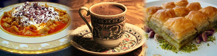
Food & Cuisine Patara
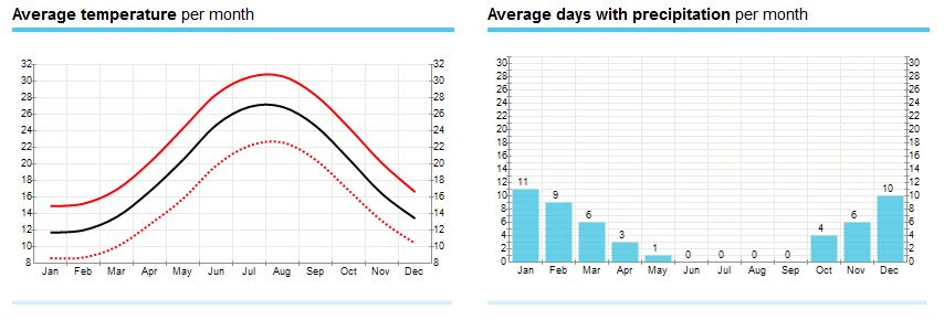
Klima & Temperaturen Patara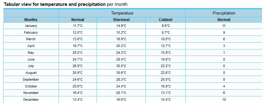
How to reach Patara
About Patara
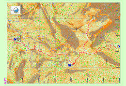
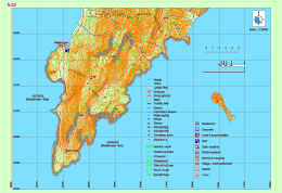
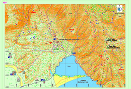
Sarıçınar – Hisarçandır
The part of the Lycian road here rises from within the valley in the National Park of Göynük Canyon to the north and turns towards the peak of Sarıçınar Mountain through the end of the valley The road becomes stabilized at the skirts of the mountain and after going through a highland settlement with a few residences, reaches the settlement of Hisarçandır, the official beginning point of the Lycian road.
It should be noted that the Lycian Road continues until the archaeological settlement of Trebenna, which is located near the Çağlarca village in Geyikbayırı, Konyaaltı district, Antalya province and is known to be the last city on the eastern side of the Lycian country. After the marking of ancient road remains which start from the settlement of Hisarçandır, goes through the archaeological settlement of Typella and the skirts of Sivridağ, and reaches the archaeological settlement of Trebenna is completed, the official starting point will become the Akdamlar village, which is nearby, and the maps will be updated in accordance with this.
Göynük Plateau – National Park of Göynük Canyon
Lycian road, which extends from the settlement of Gedelma, goes through small settlements such as Meşeçukuru, etc. and reaches the settlement Söğütçük. The common name of the settlements here is known to be the Göynük Plateau. Lycian road runs parallel to the road below and runs directly on the road below from time to time until it is separated from it and leads down to the Göynük creek.
The route goes through the creek for a while and after the creek is crossed via wooden stairs, it goes up and down a hill into another creek basin, after which a long climb starts. Trekkers who walk below from the Göynük Plateau and towards the canyon should pay attention to the information given below:
Yayla Kuzdere – Gedelma / Kuzdere – Gedelma Yol ayrımı
The western route of the Lycian road, which parts from the main road, crosses through forests, gardens and other roads from time to time and eventually reaches the settlement of Gedelma. From the Phaselis area, the road first goes through Kuzdere settlement and follows the main road which passes through the Kesme Strait and its canyon, after which it is connected with the eastern route of the Lycian road which reached Gedelma.
Lycian road, which follows the asphalt road that ascends to Gedelma, parts from it after a few hundred kilometers and continues towards the Göynük Plateau from within the forest. The best place in this section where needs for eating, shopping, etc. can be met is the Gedelma settlement.
Phaselis – Çamyuva – Kuzdere
The road begins from the archaeological settlement of Phaselis and first continues in a route parallel to the sea, then carries on towards the Kuzdere settlement through Turkish pine forests and on the banks of the creek.
Information regarding the archaeological settlement of Phaselis are provided on the page for Section 26. The settlement of Çamyuva is suitable for meeting essential needs such as food and accommodation.
IDYROS
Ancient sources do not contain much information on the ancient city of Idyros. Carl Ritter has stated it is said that “the city which is a ship haven of the ancient ages located around Egber which can be accessed by going north from Phaselis and over the northern slope of Cap Avova, is Idyros Polis”. Skylax has written that the city of Idyros is located between Phaselis (Tekirova) and Lurnateia (Sıçan [Rat] Island). Kipert has indicated that the city is in the bay on the southeastern coast of Kemer Mountain.
In 1977, as a result of the excavations carried out at the back of the Ayışığı facilities for excursionists on the coast in Kemer by the Ministry of Culture and Tourism, the city remains in this area were identified as to belong to the Idyros ancient city. The excavations revealed a Byzantine church and civil architecture structures surrounding it, in addition to tombs from classical and Byzantine periods.
Tahtalı Dağı – Yayla Kuzdere
The western route of the Lycian road continues to the north from the Beycik settlement and passes across the strait on the west of the Tahtalı Mountain. It runs through centuries-old cedar and juniper trees and snowy hollows. Eventually, the road descends onto a small plain in the middle of which a single house rests. Before arriving at this point, a path that detaches from the road can be taken to access the peak of Tahtalı Mountain.
The small plateau on which the house stands is inhabited during summer, while it is under heavy layers of snow in the winter. It provides potable water by means of the fountain between tree hollows, at the south of the house.
Read more: Tahtalı Mountain – Kuzdere Plateau Map Section 27
Tekirova – Phaselis
The eastern route of the Lycian road, which forks at Çıralı, passas through various bays on the coast and descends into Tekirova settlement. It progresses for a long while on the plain where the town is located, goes towards north and reaches the Phaselis archeological settlement. Within this section, all needs, such as food, accommodation and shopping can be met in Tekirova.
PHASELIS
Phaselis, which is within borders of Tekirova in Kemer district, Antalya province, and draws attention due to its natural beauty as well as its archeological value, was established by the Rhodians around 650 BC. The city was especially rich and powerful during the classical age. Phaselis people, who prospered by means of marine trade, are infamous due to their slyness and deceitfulness.
Ulupınar Beycik
The western path of the Lycian road (the western route), which continues through the pine forest from Chimaira (Yanartaş) to the north, passes through the Ulupınar settlement and progresses toward the settlement of Beycik by ascending within a Turkish pine forest.
The road goes parallel to the main road near the upper Beycik settlement and continues to ascend steeply towards the strait on west of the Tahtalı mountain. In the section, needs such as food, accommodation and shopping can be met in Ulupınar while upper Beycik will meet the same needs as well.
Olympos – Çıralı
The path, which arrives at the coast in the coastal settlement of Olympus, follows the Çıralı coast and forks into two routes, namely the western and eastern routes. The path following the eastern route runs near the sea at a low level, skirts around the bays and continues towards the Phaselis archaeological settlement.
The path that goes west ascends to high levels towards Ulupınar and Beycik and continues at a high level towards north in the direction of Tahtalı Mountain. There are facilities that will meet essential needs such as food, shopping and accommodation in both Olympus and Çıralı within the section.
Adrasan – Olympos
The path which comes from Adrasan, goes through the forest and climbs to the northern slopes of Musa Mountain from within the valley. It starts to descend from around the settlement of Olympus. After progressing through a landscape of sandalwood forest and continuing paralele to the creek basin at the side of the valley, the path reaches the coastal settlement of Olympus and the archaeological settlement of Corycus. There are no food or water resources along the path. The only location on which needs for food, water, etc. can be met is the coastal settlement of Olympus.
GENOESE BAY
While Genoese Bay is referred to as a safe haven in the marine guides of 14th century, the bay which is marked in the Map of Piri Reis is defined as on of the most important harbors of Lycia by some of the 19th century travelers.
Korsan Koyu – Gelidonya Feneri / Korsan (Pirate’s) Bay – Gelidonia Lighthouse
At this part of the Lycian road, the path moves from the settlement of Karaöz to the south and continues via a dirt road and parts left from this road at the end part of the peninsula. The path then ascends within the forest and arrives at a slope viewing Cape Gelidonia and the Gelidonia Lighthouse.
The path ascends a little more by following the slope of the hill, after which it starts to decline within the forest. The path then continues towards Adrasan in parallel fashion to the coast, which provides the travelers with a view of the sea for a while. Within Section 22, the only source of potable water is the fountain that is located at the ancient settlement which is indicated as Melanippe (Korsan [Pirate’s] Bay).
Karaöz – Adrasan
Because of the layout of the Lycian road sections, the Lycian road part shown in this section reaches the settlement of Karaöz from the coast and continues towards the cape in parallel fashion to the dirt road. This part is shown in Section 22. The Lycian road moves around the slope where the Gelidonia Lighthouse is located at further south and via the forest path, arrives at the settlement of Adrasan, as seen in Section 21 again. The Lycian road passes the Adrasan coast and moves upwards from the creek basin at the end of the coast.
Upon the asphalt road, at the point where the lodging houses and restaurants end over the creek basin, the Lycian road moves toward right and ascends in the direction of the Olympus settlement. The settlement of Adrasan is the only settlement within this section in which essential needs such as food, water, etc. can be met.

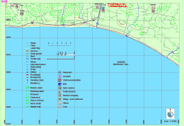
Mavikent – Karaöz
The entirety of the Lycian road within this section progresses on the coast in parallel fashion to the sea. On the coast, in the south of the Mavikent settlement, the settlement of Gagai and aqueducts can be seen. Even though the section legend includes markings indicating a grocery or settlement, it is highly probable for the settlements within this section, especially the ones on the coast, to be empty during the winter since these locations are generally inhabited during the summer for vacation purposes. Particularly, the stores for food and water can be accessed in the summer.
GAGAI
Gagai, which is located within borders of Mavikent Town in Kumluca District, Antalya Province, was established on the hill at north of the white limestone mound on the beach, the skirts of this hill and the plain in front of it. The name of the settlement is referred to as “Palaion, Teikhos or Old Castle” in ancients sources.
While most sources cite that the city’s name was derived from the word “ga” which meant “earth” in Doric, or that it was derived when a Rhodian commander named Nedius came into danger with his ship after winning a battle against Lycian and Cilician pirates and his crew shouted “ga ga” upon seeing the land, it is presumed that the name Gagai was derived from the word “hahha” which is spelled “gaxe” on coins with Lycian inscriptions and which is originated from old Anatolian languages.
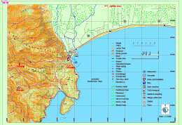
Sahilkent – Hasyurt – Kumluca
The entirety of the Lycian road that is within this section progresses on the coast, parallel to the sea. If the travelers wish to do so, they can part from the Lycian path, follow the main road to the Kumluca district and visit the archaeological settlements of Rhodiapolis and Korydalla.
CORYDALLA
Corydalla, which is located in Hacıveliler Village, expands on two hills and their skirts. Corydalla was represented in the Lycian League together with Gagai and Rhodiapolis and even though it was not the largest of the three cities, it was the leader among the three.Most of the ruins, such as the remains of the theatre, which were identified in the late 19th century and the early 20th century, could not survive until our day. The most attention-drawing structures in Corydalla are the bathhouse, waterway, the cisterns on the Small Asar Hill and the Large Asar Hill, rock tombs and a mosaic tiled building of which the walls were built with meticulous workmanship. Rather than the structural remains in it, Corydalla is essentially known for its treasure, which was dug out after an illegal excavation, of which a part was smuggled abroad and which had a special place in the Byzantine metalworking art.
Bonda T. – Finike – Sahilkent
Two paths, coming from south and north, merge further up from the Bonda Hill and around the Dinek Hill. The combined path descends to the Finike district via patches of scrub and pine woods, sometimes intersecting with dirt roads opened for vehicles. While there are no set centers of population along the Lycian road, which will be following the coast for 20 kilometers after the district of Finike, there are some summer houses on the coast.
However, it can well be said that the most suitable location for acquiring food, water, accommodation, etc. is Finike. The archaeological settlement of Arycanda, which is one of the biggest in the region of Lycia, can be accessed after an approximately 1-hour journey with vehicles via the main road that goes north within Finike. If the Lycian road is continued to be followed through Finike, the archaeological settlement of Limyra can be visited after following the creek that goes north from the Sahilkent settlement for a few kilometers.
Kınık – Yukarı Beymelek – Bonda T.
As an alternative to the northern route that can be seen in Section 16, the southern route which goes right from the bridge on the main road that provides crossing over Demre creek can be taken after the ancient settlement of Myra. The route continues along the asphalt road and ascends through the Kınık settlement that is 1,5 kilometers further; then it enters scrubland. The path, which progresses among scrubs that are the typical vegetation in the Mediterranean, reaches the main road within the village by passing in front of the Ision ruins.
The southern of the Lycian road which continues to go south (towards the sea) skirts around the lagoon by heading east after reaching the main road at the coast. The route continues on the ancient road which ascends to the east from the opposite of the strait side of the lagoon where the lagoon meets the sea and climbs up the Bonda Hill where many archaeological settlements exist.
Zeytin – Alakilise – Bonda T.
The Lycian road, which ascends via the path beside the dirt road at the exit of Belören settlement, reaches the settlement of Zeytin by passing a wide plain. After passing Zaytin, the dirt road is continued to be followed for a short while; afterwards the path to the right is taken. The path descends for some time and then enters the woods from among the village houses. At the hill, the dirt road is once again followed for a short while and then the road becomes a path again, descending to Alakilise.
After Alakilise, a gentle climb and then a steeper climb must be done. Passing below the archaeological remains known as Papaz Kayası, the path ascends to the top of the mountain. After this point, the path follows the hillsides and ascends through wooded areas with gentle slope. The northern route of the Lycian road, which descends from very high altitudes while providing a view of the lagoon before Beymelek, becomes unfavorable to walk in the winter due to snow buildup on the paths. It is advised for travelers who will be taking this route to carry sufficient water for this part which will take two days between Belören and Finike.
Gürses – Demre – Belören
If the road to the left-up is to be taken at the Lycia junction before the Andriake settlement, the pathway passing through the Sura ancient city, ascends on a canyon with an ancient stepped entry after Sura. The pathway going up from the valley joins the asphalt road and advances parallel to Gürses settlement and occasionally passes through bushes and thorn patches. The pathway advancing through cisterns and ancient ruins until the city walls above the Myra ancient city, leads to the front of Myra by descending down from the city walls.
The pathway advancing to the right (sea side) before Andriake, passes by The Church of St. Nicholaos after passing by Andriake settlement and advancing along the asphalt road until Demre city center and joins the other pathway ascending in front of Myra. If advanced to the north from this point in Demre district, Demre stream is crossed over with a bridge. At the exit of the bridge, the Lycia pathway diverges again.
Subcategories
Accommodation Article Count: 0
Tours & Activities Article Count: 1
Tours, trips Article Count: 1
Boat Tours Article Count: 0
Trekking Article Count: 0
Blue Cruise Article Count: 0
Discover Lycian Article Count: 34
|
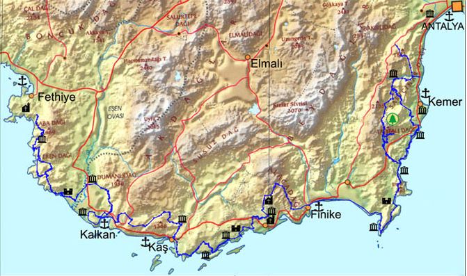
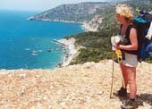
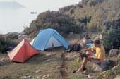
The Lycian way is a 509 km way-marked footpath around the coast of Lycia in southern Turkey, from Fethiye to Antalya. The Lycian Way is a coastal walk and mild temperatures mean it can be walked throughout the winter months. According to the Sunday Times the Lycian Way is one of the ten most beautiful long distance hikes of the world. The route is graded medium to hard; it is not level walking, but has many ascents and descents as it approaches and veers away from the sea. It is easier at the start near Fethiye and gets more difficult as it progresses. We recommend walking the route in spring or autumn; February-May or September-November; summer in Lycia is hot, although you could walk short, shady sections. The route is mainly over footpaths and mule trails; it is mostly over limestone and often hard and stony underfoot. On the first part of the route, and in Patara, Kalkan, Kas, Myra, Finike, Adrasan, Olympos, Cirali and Tekirova, you can stay in pensions or small hotels. On other nights, you may stay in a village house, or camp out. There are plenty of camping places with nearby water mentioned in the book; you do not have to ask permission to camp out.
Highlights of the Lycian Way include: |
|
Lycian Way Article Count: 31
| Teke peninsula, which is located between the Antalya and Fethiye gulfs in the Mediterranean region, was named as Lycia in ancient geography. The southern border of the region is its coast to the Mediterranean Sea, while its eastern, western and northern borders changed throughout the history. According to the ancient writers, Beydağları which start from the west of Antalya and extend to southwest, Akdağ range and their extension to the northwest defines the northern border of Lycia. In the famous epic poem Iliad, Homer states that the Lycians, which were commanded by Glaucus and Sarpedon, supported the Trojans against the Achaeans. |
Lycia came under the dominance of the Persians after 545 BC and supported the fleet that was formed by the Persian King Xerxes for the conquest of Greece in 480 with 50 ships. The Persian occupation ended when Alexander the Great crossed the Bosphorus to Anatolia and defeated the Persians in 333 BC in the Battle of Granicus. After the death of Alexander the Great, Lycia came under the dominance of Ptolemaic dynasty in Egypt, which descended from the general Ptolemy, from the year 309 BC for 100 years; this is known to be the period in which Lycian language was forgotten and replaced with Ancient Greek.
The region has been ruled by the Syrian King Antiochus III between the years of 197 BC and 167 BC. Lycia received its independence from the Roman Empire in 167 BC. During this period, 23 cities united and formed the Lycian League, of which the capital city was Xanthos. According to inscriptions and ancient coins the League had its monetary unit.
Strabo states that the six biggest cities of the Lycian League were Xanthos, Patara, Pinara, Olympus, Myra and Tlos. The Miliarium Lyciae, which is the map of the Lycian region with distance units and routes connecting the settlements, is the oldest road map known. During the Roman Empire period, the League did not lose its function and reached maximum level of prosperity during this time. The city populations were around 5,000 and the total population of the region was approximately 200,000. The borders were pushed further as to include Kaunos (Dalyan) in the northeast.
Around the middle of 5th century, there were 34 cities ruled by the Proconsul of the Lycian State. The region between Demre and Kaş was the most populated area in Lycia. The amount of settlements per kilometer is nearly 30 in this region. Introduction of Christianity to Lycians did not occur until the visit of St. Paulus to Myra and Patara at his third missionary journey between the years of 53 and 57. Methodius of Olympus was the first known bishop of Lycia and he was executed in 312. The Byzantine period between 4th and 7th centuries was the period in which Christianity was adopted and many churches were built in the region.
One of the most prominent changes that occurred during the said period was the start of monastery settlement constructions, especially in the mountainous areas of Demre. Monasteries were very important points of power which had influence on the economic and public life. The monastery life in Lycia started as early as the 5th century. The fact that many large churches were built during the 5th and 6th centuries indicates that the population of the region was very high during the said period.
Most of the Lycian coast is formed of rocky terrain. This type of topography has allowed for natural harbors to be shaped at some locations. Strabo has expressed that the Lycian coastline is rough and difficult to pass through, while the harbor is very well-equipped. Maritime trade, which existed in the region since the Bronze Age, became diversified in the following periods and lasted until the Roman and Byzantine Periods. Purple dye, cedar wood, olive oil, wine and sponges are the key goods that are produced in Lycia. According to ancient sources, high quality and soft sponges can be harvested at Antiphellus and the area surrounding it. In addition, the quality of the cedar wood in Lycia, which is used in shipbuilding is rather high as well.
The harbors in Lycia can be named as Idyros, Phaselis, Corycus, Olympus, Posidarisus, Melanippion, Gagae, Phoinikos, Andriaca, Simena, Teimussa, Aperlae, Antiphellus, Kalamaki, Phoinike, Patara, Pydnai, Arymnessos/Perdicia, Calabantia, Karmylassos, Telmessus, Krya, Lisse and Lydai, respectively from east to west.
Of these harbors, Andriaca and Patara is distinguished from the others in that they possess political and economic power, in addition to being an internationals trade point. By virtue of its local traditions and distinctive architectural style, the region is the most interesting area in Anatolia; the cities of the region are generally located on the coasts and the valleys of Xanthos and Arycandus, which are considered to be the core of the region. Some of the texts that belong to the Lycians, who were known for having their own language and alphabet, were translated into modern languages; most of these are epitaphs.
The region of Lycia consists of cities of large, medium and small scale, port cities, military zones, farm settlements and towers. Most of the visible remains in the region belong to the Roman and Byzantine periods. The most encountered types of remains in the traditional settlements concentrated in the mountains are olive oil and wine workshops, and agricultural terraces. These rural settlements, in which most of the population lived, provided food for both themselves and the large cities.
The residential structures in Lycia are generally divided into four groups. The first group consists of adjacent residences in which each room has its own entrance. The second group is made up of stand-alone residences of one or two rooms in rural settlements. Both types of residences in these groups are generally two-storey houses that are located collectively or closely within walls of the settlement. The third group consists of single-storey residences with two to four rooms in agricultural areas of which some has courtyards, cisterns and workshops, while the fourth group is made up of residences of mostly rich people in rural areas, which are built as rooms surrounding a courtyard which is positioned in the middle.
Natural disasters and epidemics that occurred in the region have deeply affected the lives of those in the cities. The most prominent of these are the earthquakes that occurred in the years 141, 240, 385, and 529, and the plagues that happened in the year 542 and the period between 1346 and 1347. Due to the blights that were suffered in the coastal regions, the settlements in the inland areas came into prominence. Emperor Constans II fought the Arabians in 655 on the coast of Phoenix with the fleet he personally commanded. After being defeated, the Emperor managed to survive by way of the self-sacrifice of a young soldier. After this battle, the Arabians began navigating freely near the Mediterranean coasts.
In 802, the regions of Lycia and Caria were occupied by the Abbasids. During the 10th century, Lycia and the whole of the Mediterranean region were under the domination of the Byzantine Empire. Turks acquired access to Lycia after the Seljukian Sultan Kılıç Arslan II defeated the Byzantine army. After 1204, the whole of Lycia came under the domination of Turks.
Mountainbike tours Article Count: 1
Vacation Spots Article Count: 37
Kaş Article Count: 7
Olympos/Çıralı Article Count: 6
Kalkan Article Count: 6
Patara Article Count: 6
Kekova Article Count: 6
Demre/Hoyran Article Count: 6
Demre/Hoyran
Right_EN Article Count: 0
accordion-category-EN Article Count: 9

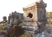
All pre-Greek peoples of Anatolia excelled in building monumental tombs associated with some form of ancestor worship; the Phrygians, Carians and Cilicians had their distinctive styles. The Lycians, however, developed this tradition to its artistic perfection. The landscape of Lycia is thoroughly marked by their strange, evocative and beautiful funerary monuments. Lycian tombs come in three major types. Visually the most striking are no doubt the rock tombs -more or less elaborate funeral chambers carved directly from the rock, usually into a cliff. The oldest of these are simple pigeon-hole cubicles of the sort best viewed in Pinara. More commonly, the graves are fashioned like the facade...
» Read more ..
If you really want to get a feel for southwestern Turkey’s Mediterranean coast, you have a great option: Hike the 300-mile Lycian Way, which stretches from Ölüdeniz to just shy of Antalya. Opened in 2000 as the country’s first long-distance trail, it’s been ranked one of the “World’s Ten Best Walks” by the Sunday Times. The route has many inland sections but provides plenty of awesome sea views from ridges and mountains high above the water, and also passes through plenty of ruins. It takes its name from Lycia, an ancient kingdom based in the region as far back as the 15th century BC. Budget 20-30 days to walk the entire trail, or explore shorter sections on day hikes out of towns like...
» Read more ..
There are 3 paragliding centers in Lycia: Oludeniz (near Fethiye), Kaş and Olympos.Oludeniz is one of the best places in the world for paragliding and in the last ten years has become a mecca for paragliders from all over the world. Incredible thermals and ideal conditions make for amazing flights from Babadag Mountain down to beautiful Oludeniz beach with its long stretch of white sand and turquoise blue water.The International Oludeniz Air Games Festival is held every year at Oludeniz beach. Lots of fun stuff to do and see.Kaş and Olympos also offers spectacular paragliding over the mountains and sea. Tandem paragliding isn't scary and is surprisingly relaxing. * Paragliding in the...
» Read more ..
Crystal clear diving in the Mediterranean Sea... The crystal clear sea offers excellent diving conditions with high amount of underwater life, visibility up to 40 meters and beautiful underwater rocky landscapes. You just won’t find coral reef here. In September/October the water temperature is ideally at 27°C!There are about 30 dive sites, reachable within 20/30 minutes from the port of Kas. The variety is quite impressive, you can go wreck-diving, cave-diving and you can swim through canyons and tunnels.If you are lucky, you might see dolphins, a Mediterranean monk seal, octopus or maybe even a seahorse (I did! but the poor thing with a dozen of divers taking pictures of it…). The...
» Read more ..
Kas is the last county town located on the south-west cost of Antalya. Antiquity name of Kas was Antiphellos (facing Phellos). As written on ancient sources; Antiphellos means “the extension of Phellos on sea” or the “coast of Phellos (stony place)”. Antiphellos is now a village located on the north of Kas and called Cukurbag. * Read More: What to know in Kaş * Restaurants, Cafés, Bars & Mayhanes in Kaş/ MAP & LIST * Hotels, Pansions, Camping Sites in Kaş / MAP & LIST
» Read more ..
A small peaceful Mediterranean resort and fishing town on the beautiful Turquoise Coast of Turkey, Kalkan has not been touched by mass tourism. More sophisticated than the usual resort town, Kalkan appeals to travelers looking for more than a “sun and sea” holiday. According to the Sunday Times, Kalkan attracts the kind of visitor who would also enjoy Tuscany or the Dordogne. The Guardian likens the town to “the Italian Riviera minus the poseurs.” Because of its great charm, Kalkan has a growing number of perennial visitors who say the town is the only holiday destination they would choose to visit repeatedly. There is simply no other town quite like Kalkan along Turkey’s coast. "Mouse"...
» Read more ..
Kekova, with its picturesque islands and intriguing sunken city* Read More: What to know in Kekova * Restaurants, Cafés, Bars & Mayhanes in Kekova/ MAP & LIST * Hotels, Pansions, Camping Sites in Kekova/ MAP & LIST
» Read more ..
* Read More: What to know in Olympos and Çıralı * Restaurants, Cafés, Bars & Mayhanes in Olympos and Çıralı/ MAP & LIST * Hotels, Pansions, Camping Sites in Olympos and Çıralı / MAP & LIST
» Read more ..
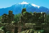
The name Patara stands for a marvellous 12 km white sandy beach which is classed as one of the most beautiful beaches in the world and for the ancient ruins of the ancient town still partly buried under the sand. The beach is also a nesting place for turtles and is therefore environmentally protected. The ancientcity of Patara, the birthplace of St.Nicholas and the port where St.Paul changed ships on his way to Tyros is in recent years being carefully excavated by Prof. FahriIşık. Patara used to be the most important harbour of Lycia and one of the major members of the Lycian League with three votes. During its eventful history the city always had to struggle against foreign...
» Read more ..